Alpha quality?
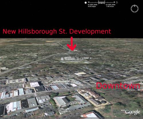
This is my first release of a “fly-by” created with Google’s mapping tool Google Earth [v4.0291.beta], drawing tool SketchUp and published concept plans to model new development in our community. In this case, modeling RAM Development’s 322 luxury condos visual impact.
The large McMansion-like teardown, unfortunately, is displacing Hillsborough Street’s affordable 111 unit Town House apartments. Town House has been a low cost haven for students for years.
Hillsborough425 aka “The Residences at the Grove” (again, what grove?) will be the largest development of its kind to bless (?) Chapel Hill. Given that and RAM Developments close relationship with Council in the ongoing $100M deconstruction of downtown, the Mayor’s brush-off of greater transparency is troubling.
How did I do it?
Tools:
Input:
- Hillsborough425: Current Town House Apt. layout [GIF]
- Hillsborough425: Sept. 2006 Site Plan [JPG]
- Hillsborough425: Concept Plan Application [PDF]
- Other supporting documents.
![Hillsborough425: Sept. 2006 Site Plan [JPG]](http://townhall.townofchapelhill.org/agendas/2006/09/18/5/5-8-5_site_plan.gif)
![Hillsborough425: Concept Plan Application [PDF]](http://townhall.townofchapelhill.org/agendas/2006/09/18/5/5-8-5_site_plan.gif/5-6_concept_plan_application.pdf)
Output:
Using Google Earth:
- 1) “Flew” to the general location of Hillsborough425.
- 2) Added Hillsborough425: Current Town House Apt. layout [JPG] as an overlay, changed its opacity to %50, then stretched and rotated it until the roads and features matched up.
- 3) Set the overlay to be drawing priority #1.
- 4) Added Hillsborough425: Sept. 2006 Concept Plan [GIF] also as an overlay and adjusted it in a similar manner using both the underlying GoogleEarth features and the current layout overlay.
- 5) Toggled off the Town House Apt. overlay leaving just the concept plan.
- 6) Saved the result safely to disk.
![Hillsborough425: Current Town House Apt. layout [JPG]](http://citizenwill.org/hillsborough425/maps/Hillsborough425Existing.jpg)
![Hillsborough425: Sept. 2006 Concept Plan [GIF]](http://citizenwill.org/hillsborough425/maps/HillsboroughConcept_5-8-5_site_plan.gif)
Using Google Sketchup:
- 1) Imported the current view from GoogleEarth (the Hillsborough425 concept plan overlaid on the current topography)
- 2) Toggled Google->Terrain OFF
- 3) Outlined the buildings using the flattened concept plan imported from Google Earth and tracing with the LINE tool.
- 4) Using the Hillsborough425: Concept plan descriptions and other documents as references for each buildings height, used the PUSH/PULL tool to extrude a volume roughly the same height.
- 5) Toggled Google->Terrain ON
- 6) Using the SELECTION tool to select an element in one building, right clicked and selected all connected components. Once selected, used the MOVE tool to place the building roughly at grade.
- 7) Exported the finished product to GoogleEarth.
Once exported to GoogleEarth, I finished by exporting my alpha-quality project as a KML suitable for GoogleEarth v4.0291.beta.
If I get some time this weekend (ha!), I’ll add in the existing two and four story apartments for scale.
Here’s the Sketchup files ( [1] and [2]) of the Hillsborough425 buildings, please feel free to build upon my initial effort.
My only request is you publish the results for the wider community.
Leave a Reply
You must be logged in to post a comment.