Google has chosen Kansas City, Kansas as their partner in deploying 1 gigabyte/second network services to the community. Chapel Hill applied with some gusto several years ago for the “honor”. At the time I argued that while it would be nice to have the financial backing of Google, Google’s reticence in discussing privacy, security and local control made a possible deal problematic.
The Town continues to limp along with its joint fiber optic deployment project with NC-DOT. What is missing, still, is any real effort by the Council to form a community-based advisory group for leveraging that public investment in high speed networking to attract economic development or increase access throughout our Town’s neighborhoods.
Maybe with Google off-the-table we will finally put the attention into the fiber project I called for over 9 years ago when I started pushing for municipal broadband.
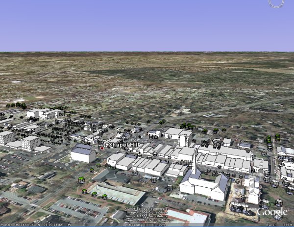
Making some progress on a GoogleEarth visualization of downtown.
Here’s some data if you want to either visualize Chapel Hill within GoogleEarth or want to start fresh with a re-import. Small caveat on the GoogleEarth import – don’t turn on the terrain as I still need to tweak the elevations to get the right output.
If anyone manages to adjust the terrain before Sunday, please consider routing the changes back my way….
Hope to have Granville Towers and RAM’s Lot 5 proposal by Sunday. And, with any luck, a decent flyby to demonstrate the visual impact of the 104′ leviathan.
This is still very raw, but I thought I’d put out this demo to stir some thought within the community. Visualization tools like GoogleEarth (GE) can help remove some of the difficulty in assessing the visual impact of new development.
Our town’s planning department has the raw data needed to create a GoogleEarth representation of our town which I plan to massage and then release into the public domain for other citizens to elaborate on.
Why GoogleEarth?
While GE is a proprietary tool, the datasets it uses are exportable. So, Google owns the tool, not the data.
Our planning department should be creating GE or NASA Wind World representations of Chapel Hill as a matter of course – it would help both them and the community create a common visual-based framework for development discussions.