Friday, September 22nd, 2006
Daily Archive
Fri 22 Sep 2006
One of my readers was slightly confused about whether the fly-by of Hillsborough425 documented in my post Hillsborough425: Google Earth Fly-By, Alpha Quality was live or not.
Yes it is!
If you have the proper version of GoogleEarth installed ( GoogleEarth v4.0291.beta ), then opening this link will crank up the application and display the maps.
Alternatively, you can download the KMZ file and open it in GoogleEarth.
In either case, once the fly-over/fly-by is open, you can play around with the map views by toggling Hillsborough425: Existing Town House, Hillsborough425ConceptPlanSept17th and Hillsborough425 GoogleEarth under GoogleEarth’s Hillsborough425 folder.
You can also start with a long view oriented from the North of the site by clicking on North Entrance Chapel Hill.
Any questions? Please post a comment, I’ll be happy to help.
Fri 22 Sep 2006

From Sept. 18th’s Daily Tar Heel by kind permission of Mason Phillips.
Nice to see a shout-out to my series on the poor decision to go with the proprietary lock-in NextBus system over an open-standards system. An alternative standards-based system could’ve delivered Internet access along all 23 transit routes – an alternative providing excellent penetration of free communication services into the most under-served of our neighborhoods.
Fri 22 Sep 2006
Smoozefest or snoozefest, either way this weekend’s (Sept. 24th-26th [correction]) trip to Madison by our local “usual suspects” appears to be more about building relationships at home than abroad.
Most of all, this trip is about building relationships. Not only will participants gain knowledge of what has worked and what has not worked in Madison, but a synergy will be created by our trip attendees working, traveling and discussing issues together.
This trip is not a place for any decisions to be made about our future, but rather a place to make connections and gather valuable information. Learning from the perspectives and ideas of other leaders in the community will help to ensure that our community grows and sustains itself.
LTE to CHN from Mariana Fiorentino,
Chair of the Trip Planning Committee and 2004’s Realtor of the Year
Maybe joyous, interesting and possibly rewarding (or not), I hope folks aren’t going expecting to later trade upon the stronger bonds Smoozefest is supposed to engender.
Even as national scenes of “Ney Money Go” spawned by Abramoff’s scandalous behavior continue, the lure of the private/public “business” junket cannot be diminished.
And “business”, local business, forms the continuous sub-text of this jaunt.
The purpose of the Intercity Visit and Leadership Conference is to convene leaders of the Chapel Hill and Carrboro community to learn from the experiences of another successful community and to build relationships among participants that will help us successfully address our community’s challenges and opportunities.
(more…)
Fri 22 Sep 2006
Alpha quality?
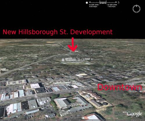
This is my first release of a “fly-by” created with Google’s mapping tool Google Earth [v4.0291.beta], drawing tool SketchUp and published concept plans to model new development in our community. In this case, modeling RAM Development’s 322 luxury condos visual impact.
The large McMansion-like teardown, unfortunately, is displacing Hillsborough Street’s affordable 111 unit Town House apartments. Town House has been a low cost haven for students for years.
Hillsborough425 aka “The Residences at the Grove” (again, what grove?) will be the largest development of its kind to bless (?) Chapel Hill. Given that and RAM Developments close relationship with Council in the ongoing $100M deconstruction of downtown, the Mayor’s brush-off of greater transparency is troubling.
How did I do it?
Tools:
Input:
Output:
Using Google Earth:
- 1) “Flew” to the general location of Hillsborough425.
- 2) Added Hillsborough425: Current Town House Apt. layout [JPG] as an overlay, changed its opacity to %50, then stretched and rotated it until the roads and features matched up.
- 3) Set the overlay to be drawing priority #1.
- 4) Added Hillsborough425: Sept. 2006 Concept Plan [GIF] also as an overlay and adjusted it in a similar manner using both the underlying GoogleEarth features and the current layout overlay.
- 5) Toggled off the Town House Apt. overlay leaving just the concept plan.
- 6) Saved the result safely to disk.
Using Google Sketchup:
- 1) Imported the current view from GoogleEarth (the Hillsborough425 concept plan overlaid on the current topography)
- 2) Toggled Google->Terrain OFF
- 3) Outlined the buildings using the flattened concept plan imported from Google Earth and tracing with the LINE tool.
- 4) Using the Hillsborough425: Concept plan descriptions and other documents as references for each buildings height, used the PUSH/PULL tool to extrude a volume roughly the same height.
- 5) Toggled Google->Terrain ON
- 6) Using the SELECTION tool to select an element in one building, right clicked and selected all connected components. Once selected, used the MOVE tool to place the building roughly at grade.
- 7) Exported the finished product to GoogleEarth.
Once exported to GoogleEarth, I finished by exporting my alpha-quality project as a KML suitable for GoogleEarth v4.0291.beta.
If I get some time this weekend (ha!), I’ll add in the existing two and four story apartments for scale.
Here’s the Sketchup files ( [1] and [2]) of the Hillsborough425 buildings, please feel free to build upon my initial effort.
My only request is you publish the results for the wider community.



![Hillsborough425: Sept. 2006 Site Plan [JPG]](http://townhall.townofchapelhill.org/agendas/2006/09/18/5/5-8-5_site_plan.gif)
![Hillsborough425: Concept Plan Application [PDF]](http://townhall.townofchapelhill.org/agendas/2006/09/18/5/5-8-5_site_plan.gif/5-6_concept_plan_application.pdf)
![Hillsborough425: Current Town House Apt. layout [JPG]](https://citizenwill.org/hillsborough425/maps/Hillsborough425Existing.jpg)
![Hillsborough425: Sept. 2006 Concept Plan [GIF]](https://citizenwill.org/hillsborough425/maps/HillsboroughConcept_5-8-5_site_plan.gif)